There is a stereotypical image of flat lands, cornfields and a general blandness when picturing the state of Indiana. Bloomington, like much of southern Indiana, goes against that notion.
Bloomington seems like an entryway to the hills of southern Indiana. It's a city shrouded in nature. The city sits at the cusp of state and national forests, as well as two state parks known for rolling hills and fall foliage. Bloomington is also close to Lake Monroe and several smaller dazzling lakes.
So while you're here, get to know Bloomington's corner of southern Indiana on foot or bike. Here are three options of each to start you off, but there are infinitely more to explore.
Running Routes
All routes begin and end at the Sample Gates located at the intersection of Kirkwood and Indiana avenues.
IU Athletic facilities loop Get a 360-degree look at Memorial Stadium and the other IU athletic centers.
Paved loop route, relatively flat or downhill, about 3.8 miles
1. From the Sample Gates, head north on North Indiana Avenue.
2. Turn left at the intersection of North Indiana Avenue and East 17th Street, and head toward the stoplight intersection of East 17th Street and North Dunn Street.
3. Cross the road and run north, down North Dunn Street. On your right is Memorial Stadium.
4. Turn right at the intersection of North Dunn Street and East Matlock Road, and run east for another view of Memorial Stadium.
5. Turn right at the intersection of East Matlock Road and Fee Lane, and head south. Bart Kaufman Field and Andy Mohr Field, which house IU baseball and softball, respectively, will be on the right. This long stretch also includes the IU Tennis Center and Gladstein Fieldhouse indoor track on the right. The entrance to Billy Hayes Track at the Haugh Complex and the home to the Little 500 cycling race and soccer's Yeagley Field at Armstrong Stadium are on the left.
6. Turn right at the intersection of Fee Lane and East 17th Street, and run west. The newly renovated Simon Skjodt Assembly Hall is on the right.
7. Turn left on North Indiana Avenue at the intersection of East 17th Street, and head back south until you reach the Sample Gates.
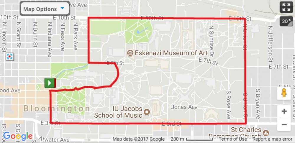
Getting to know campus route Check out the castle-like academic buildings and marvel at landmarks such as the iconic red clocks and Herman B Wells statue.
Paved loop route, some elevation, about 3.1 miles
1. From the Sample Gates, head south on South Indiana Avenue. You will pass Bryan Hall and the Maurer School of Law. If you look closely, the Kirkwood Observatory is hidden inside Dunn Woods.
2. Turn left on East Third Street and South Indiana Avenue, and run east. This is a long stretch with many big academic buildings. There are red signs outside each building displaying the names. Don't miss the red clock to the side of Swain Hall East or the Jordan Hall Greenhouse. On the right side of the road, there are many fraternities and sororities.
2. Turn left, and head north on South Union Street. Many residence halls are situated on this edge of campus.
3. Turn left on East 10th Street, and run west for views of more residence halls. Enjoy the downhill past Herman B Wells Library and the arboretum. Don't forget to glance to the right for Kelley School of Business' Hodge Hall and other academic buildings. There is a fun sculpture of a brain by the psychology building.
4. Turn left at North Woodlawn Avenue toward the Indiana Memorial Union. Collins Living-Learning Center is on the right. It has a dining hall decorated to look like the Great Hall from the "Harry Potter" movies.
5. Turn left onto East Seventh Street, and head up the hill. The Union is on the right, and on the left is one of two recreational centers on campus.
6. Follow the downhill right on North Forest Avenue, then follow the road around and back up the hill to Ballantine Hall. Check out another red clock on the left and Beck Chapel on the right.
7. At the top of the hill, turn right on South Woodlawn Avenue. Keep going up, past the parking lot and onto the red-brick path. This path will pass the Herman B Wells statue, which honors the former IU president. As you near the Sample Gates, the new Media School at Franklin Hall is on the right. Stop in for a drink of water and to peek at the 24-by-12-foot television screen in the center of the school.
Trail running at Griffy Lake There are several marked trails at Griffy Lake Nature Preserve, just north of campus.
"There are some awesome trails up there to run on that are moderate, some roots and some hills," IU Run Club president and junior Aubrey Curl said in an email.
Biking Routes
All routes begin and end at the Sample Gates located at the intersection of Kirkwood and Indiana Avenues.
Sample of Southern Indiana This bike route showcases a bit of everything in southern Indiana – rolling hills, dense forests, vast lakes, waterfalls and creeks. It's particularly beautiful in the morning when the fog hangs over Griffy Lake.
Paved loop route, steep hills, mild traffic in residential areas with no bike lanes, about 9.7 miles
1. From the Sample Gates, ride north on North Indiana Avenue.
2. Turn right on East 17th Street, and ride east.
3. Turn left at the stoplight on Fee Lane. Continue to the next stoplight, and wait to cross over East Matlock Road.
4. Cross the highway onto North Headley Road, and follow it to the right. Stay on this winding road through the cozy neighborhoods, then enjoy the downhill into the view of Griffy Lake. After crossing the bridge, get ready to climb the steepest hill of the route. Continue to follow North Hinkle Road until you reach a left-right only intersection.
5. Take a left on East Bethel Lane, and ride west until the next left-right only intersection.
6. Take a left onto North Old State Road 37, and enjoy the downhill. Wait at the intersection to cross over North Walnut Street into Cascade Park. Follow the road all the way to the exit on North College Avenue.
7. Take a right, and ride south on North College Avenue.
8. Turn left on West Kirkwood Avenue, and coast your way back to the Sample Gates.
Swartz A popular route to Lake Monroe, named by practicing Little 500 teams.
Paved loop route, steep hills, mild traffic, about 18.2 miles
1. From the Sample Gates, ride north, and cut right through Dunn Woods.
2. Exit Dunn Woods past the Union, and get on East Seventh Street. Ride east.
3. At North Hillsdale Drive, turn right and follow the road, crossing over East Third and East Second Streets.
4. At the intersection of South Woodcrest Drive and East Woodbine Drive, turn left.
5. Turn left again onto East Covenanter Drive, crossing South College Mall Road. To continue on East Covenanter Drive, you will turn right on South Clarizz Boulevard, then quickly left back on the road.
6. Turn left on South Fenbrook Lane.
7. Turn right on South Smith Road.
8. Turn right, and ride south on South Smith Road.
9. Turn left on East Moores Pike, and ride east.
10. Turn right on Knightridge Road, and ride south.
11. Take a right on Swartz Ridge Road.
12. Take a left, and ride south on East Moores Creek Road.
13. Turn right at East Stipp Road, and follow it west.
14. Turn right on South Harrell Road, and ride north.
15. Turn left at East Rhorer Road, and ride west.
16. Take a right on South Sare Road.
17. Go right on South Mill Stone Way to Alcott Park's Jackson Creek Trail. Follow it north to East Elliston Drive, and follow it west.
18. Turn right on South Bainbridge Drive, and ride north.
19.Turn right on East Allendale Drive, and ride north.
20. Take a left on East Winslow Road.
21. Take a right on South Highland Avenue, and ride north.
22. Take a left on East Miller Drive.
23. Go right on South Huntington Drive, and ride north.
24. Turn left on East Hillside Drive.
25. Go right and north on South Woodlawn Avenue.
26. Take a left on East Third Street, and ride west.
27. Go right on South Indiana Avenue back to the Sample Gates.
Lake Lemon Supposedly includes the best road to bike on in Bloomington, South Shore Drive. It should be obvious as to why when you cross Lake Lemon.
Paved loop route, steep hills, mild traffic, about 30.5 miles
1. From the Sample Gates, ride north on North Indiana Avenue.
2. Turn left, and ride west on East 10th Street.
3. Go right on North Walnut Street, and ride north.
4. Cross Miller Showers Park at the bottom onto North Old State Road 37. Ride north through Cascades Park, and cross North Walnut Street to continue northeast on the road.
5. Turn right on East Robinson Road, and ride eastward.
6. Turn left, and cycle north on North Tunnel Road.
7. Go right at East South Shore Drive, and go east toward Lake Lemon.
8. Turn left on State Road 45, moving southwest. Stay on 45 all the way to New Unionville.
9. Turn left on East Bethel Lane to stay on 45. This road turns into East 10th Street.
10. Turn left into Dunn Woods near the Union, and head back to the Sample Gates.
eabshire@indiana.edu
@emily_abs
Route ideas were contributed to by Patrick Wisdom, Jetblach Cycling rider and IDS copy chief and Noble Guyon, Cutters Cycling rider and IDS photographer.


